Under the auspices of the Canadian Institute in Greece (CIG) and with the kind permission granted to us by the 11th Ephorate of Prehistoric and Classical Antiquities at Chalkis (IA EPKA) and its ephor Mrs. R. Kolonia, the Southern Euboea Exploration Project (SEEP) was able to continue work in the area of Karystos in July and August of 2007. The project was partially funded by the Institute for Aegean Prehistory (INSTAP). The primary focus in 2007 was fieldwork consisting of survey in the alluvial plain (Kampos) west of the town of Karystos. This season saw the continuation of the project which SEEP began in 2006 and completes the planned two-season fieldwork component of the project. The work was made possible and greatly facilitated by the help from Ms. Maria Kosma, the epimeletria for the region as well as Mrs. Sofia Stambelou and Mrs. Evangelia Athanasiou, the museum guards at Karystos. Our special thanks go also to Mrs. Maria Chidiroglou of the Hellenic Ministry of Culture for serving as the co-field director of the SEEP Kampos survey.
Work in the field
In July and August of 2007 members of SEEP continued the survey of the Kampos plain west of Karystos. Maria Chidiroglou and Zarko Tankosic served as the co-field directors of the project. Members of the surveying teams were: Chaya Litvack, Hather Kehres, Lina Kokkinou, Kristen Mann, Melissa Lemieux, Mia Toftdal, Rachel Vykukal, Renate Storli, Rie Larsen, Svein Hauge, and Mark Tassone. Ms. Heather Kehres also served as an associate field director and we would like to especially acknowledge her contribution to the project.
The fieldwork was conducted in the course of five weeks in July and August of 2007. The goals of the survey were same as those of 2006: to examine a hitherto archaeologically poorly known part of the Karystia; to methodologically and spatially connect the previously surveyed areas in the region where different survey methods were employed (e.g., the Bouros-Kastri region to the east and Paximadhi peninsula to the south); to test the hypothesis that in an alluvial plain like the Kampos the probability of finding sites increases in the vicinity of modern roads and paths, gullies, and the foothills of the surrounding hills; and to test the hypothesis that some of the modern routes were also used in ancient times.
Methodologically, the season of 2007 was very different from the one in 2006. The entire survey area was divided into arbitrary 100x100m squares, which were then surveyed independently or in clusters using the stratified sampling approach. “Stratified sampling” in this particular case meant that the squares to be surveyed were not chosen randomly, but with respect to specific predetermined rules. In this case the squares were selected so as to include all the geomorphological features present in the survey area (e.g., southern foothills, northern foothills, central flat plain, proximity to the sea, ravines, gullies, water courses, roads). Square selection also took into account information recorded on the findspots and transects of the 2006 field season. The 100x100m squares were further divided in ten 10m wide and 100m long transects, each surveyed by a team member. Moreover, each transect was divided into five 20m long sections, which served as the basic recording units in the field. Although intensive collection of material was carried out on all of the findspots, the thin material scatter along transect and between findspots was recorded, but not generally collected. Non-findspot collections included diagnostic sherds, and lithics. The collected material was washed, preliminarily categorized, and prepared for storage and further study.
The survey area is spread over the following 1:5000 topographic maps: 6541/5, 6541/6, 6541/7, 6541/8. Approximately forty percent of the designated survey area was surveyed using the 100x100 grid system, which is a sample larger than expected and sufficient for further statistical and predictive analysis. A total of 16 findspots were discovered during the 2007 season. The names of the findspots are in the form of a unique code consisting of the year of the survey (07), location in relation to the main modern road (North or South of it), and an independent running number (01 through 99).
Preliminary results
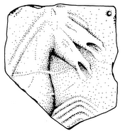
The preliminary results of the 2007 season suggest that the use of the Kampos in antiquity was more intense than previously expected. Of the 16 newly recorded findspots, as many as 11 are either prehistoric or have a prehistoric component in addition to material of later periods. This was a surprise because it was believed that most prehistoric findspots in the Kampos are covered by recent or ancient alluvium. The prehistoric findspots are characterized by almost complete lack of pottery and they consist mainly of lithic scatters (overwhelmingly obsidian). This is another unexpected and somewhat unusual feature which also seems to be typical for prehistoric findspots in the Kampos. It suggests that the area of Karystia played an important role in the prehistoric (mostly likely Final Neolithic and/or Early Bronze Age) obsidian trade and was, if nothing else, an important consumption center. Although the findspots of later date are not as numerous as those with a prehistoric component, a relatively dense scatter of post-prehistoric material was discovered in the area between findspots as “background noise.” This material, which we will begin to process and analyze next year, will provide important information on the use of the Kampos during Classical, Hellenistic, Roman, and post-Roman times. The Kampos area, being the main cultivation plain of the Karystian chora, could not have failed to attract the attention of the ancient peasant or citizen landowner's attention. Old and sporadic new finds, like a cipollino fragment of an ancient mill (trapetum) and a limestone fragment probably of a grave stone, built into a modern sheep shed, serve as indications of continuous use and cultivation of the area from Late Classical to Early Roman times.
Zarko Tankosic and Maria Chidiroglou